Well the models keep slowing things down and overdoing moisture as usual. I'm thinking about meandering out west Sunday afternoon and be near Watertown, SD around 4 pm. Not going to try too hard on this one. I would just like to enjoy the day with my wife, stop and eat, take some scenery shots, etc. I think storms might be a little more isolated than expected, at least in the first few hours, which is fine with me, just hoping I'll be in position to get on a good one early.
I suspect SPC will move the slight a little west in the next outlook. Can't see this being more than a 5% tornado day though. But what do I know.
Another tempting target is extreme SE South Dakota all the way down the Nebraska/Iowa state line, but the cap looks stronger down there and upper level wind support is really suspect. Low level hodographs are a lot nicer looking in this area. I have a feeling this is where TVN will be, and it's tempting, but it's a long drive and I'm limited on time because of family/church commitments Sunday morning.
If I could find a nice, isolated, photogenic, elevated supercell I would be completely happy.
Saturday, May 30, 2009
Thursday, May 28, 2009
Hope springs eternal
If I were a chasecation type guy, I'd be thinking long and hard about next week. Wow at the potential. 3000 joules of cape all over the map, nice southwest flow towards the end of the week, good moisture, temps high enough to break the cap, crazy warm front draped across the center of the country all week... I wonder if June is going to try and make up for May.
Sunday looks like a real chase day for us here in MN. There's enough interesting features on the models to perk my ears up for Sunday night. Hints of a shortwave rippling down the warm front in southern MN at just the right time, enough suggestion of backing winds that it has my attention. The cap is worrisome, but there is hope. Looks at least like the cold front will light up, and if that's all we have, I won't mind it all all. Not one single decent event this year, so I'm chomping at the bit.
I'm still a terrible forecaster, but I think we finally have a decent chaseable setup. Time to make sure the gear is working...
Sunday, May 24, 2009
Silly GFS
So seriously. How many of you chasers out there twitched just a little bit this morning when you saw this?

C'mon, admit it, I know you peeked...ha ha. If this did verify, I'm taking bets as to how many chapters the FCST thread on Stormtrack will have... Personally, I hope it means at least that the ridge is trying to break down.
4/24/09 Iowa Chase
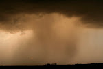
Thought I'd get this up since it turns out this is the highlight of 2009 so far (!) Unidirectional winds+ ridiculous temp/dewpoint spreads = nosebleed storms with stretched out updrafts that produced marginal winds and hail. Still, it was fun to test the equipment in preparation for the 2010 season... ha.
Initation near Clear Lake
 At least we had good background lighting
 Best looking storm of the day that died before we could play in it
 This one was fun, had some pretty cool motion


My best shot of the day
Driving home, why not sample some hail?
 This had better not become the highlight reel of 2009!
Initation near Clear Lake
At least we had good background lighting Best looking storm of the day that died before we could play in it This one was fun, had some pretty cool motionMy best shot of the day
Driving home, why not sample some hail?
This had better not become the highlight reel of 2009! Thanks Sara for your awesome driving skills!
Saturday, May 23, 2009
Monday's "potential" and blogging in general
So a lot of my friends tell me to start a blog. OK, hey, whatever. I'll give it a shot. Many ask about the weather and what it's going to do, well, I'm new at this, not a good forecaster, and I have the annoying tendency to wishcast a lot.
Suffering through the worst spring for severe weather I can ever remember. I've gone from high expectations in March, to hopefulness in April, to wishcasting in May. Now I'm just praying for rain. It's May and the lawn looks like it's August, the weather pattern looks like it's August, this is ridiculous. The only real active weather looks like it's up near the Arctic Circle.
So we have some potential for thunder at least come Monday. Instead of letting the models tell me it's going to stink, I have resorted to trying to find any glimmer of hope wherever I can. Won't be able to go far Monday, so here's to hoping some kind of instability can build closer to home along the cold front and we at least get a decent linear mess. I can't believe I just said that. But that's how far my expectations have fallen this year.
I have spent a lot of time over the last 2 years building my knowledge, observing, chasing a little, so as to be ready to do some serious chasing this year, and wouldn't you know it, there's nothing to chase. So, I apologize to those annoyed by my constant wishcasting, it's just a bit of a bitter pill to swallow...
It's hard to even look at the GFS beyond 4-5 days any more. Yeah, I checked it out this morning, and yes, it wants to toy with me yet again... hopefully it's on to something. More than likely it's just another teaser.
Subscribe to:
Posts (Atom)