Well the models keep slowing things down and overdoing moisture as usual. I'm thinking about meandering out west Sunday afternoon and be near Watertown, SD around 4 pm. Not going to try too hard on this one. I would just like to enjoy the day with my wife, stop and eat, take some scenery shots, etc. I think storms might be a little more isolated than expected, at least in the first few hours, which is fine with me, just hoping I'll be in position to get on a good one early.
I suspect SPC will move the slight a little west in the next outlook. Can't see this being more than a 5% tornado day though. But what do I know.
Another tempting target is extreme SE South Dakota all the way down the Nebraska/Iowa state line, but the cap looks stronger down there and upper level wind support is really suspect. Low level hodographs are a lot nicer looking in this area. I have a feeling this is where TVN will be, and it's tempting, but it's a long drive and I'm limited on time because of family/church commitments Sunday morning.
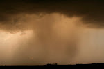
If I could find a nice, isolated, photogenic, elevated supercell I would be completely happy.
Subscribe to:
Post Comments (Atom)
Nice photogenic elevated supercell is what today is going to be all about!
ReplyDelete