And now it's canine trapping season.
Just thought I'd post a little video. Instead of ranting about the lies and general poop that PETA and HSUS throw in our faces, maybe this will make a better impression on those who may be anti-trapping or at least skeptical.
Just remember folks, for every coyote I catch, I probably save 3-4 red fox. Coyotes do not belong here or anywhere east of the Mississippi, and have become a plague on urban America. I will continue to kill every one I can as long as I can.
Trapping remains a valuable wildlife management tool. I can't put it simpler than that. Man is the apex predator, and until the saber tooth tiger is re-introduced, this will always be the case.
Watch the vid and maybe take something from it:
Thanks.
Friday, October 23, 2009
Tuesday, September 29, 2009
What a September
If you like perfect sunny weather, no rain, and complete lack of anything interesting.
Thus my lack of posts here. Sorry, just not much to write about, besides the usual SDS-induced flame wars on Stormtrack, which was an interesting diversion for one afternoon.
Critter killing season is coming, so maybe I'll have to move on to updates on that. In the meantime, fall severe season is starting with a bang and my friends down south look to have a couple decent chases in the works over the next week to ten days. Good luck everyone and I'll wait for the pictures. Thinking about turning my data off up here and settling in for another long winter.
Monday, August 10, 2009
8/08/09 Minneapolis tornado
I was at home. Yeah, didn't head out. To be honest I was nervous, my wife was nervous, and I decided to play intercept if anything came close, which looked like a real good possibility. I had no desire to be caught out somewhere while my neighborhood was trashed- every chaser's nightmare I think. Wife and kids come first, not that I would have been able to do much if it had happened, but I felt better being with them...
After a while I started thinking cap bust so I really felt good about my decision. When the storm fired I could have easily shot down 10 or 169 and been in perfect position, but in a traffic-clogged Saturday evening metro mess there was just no way... and I'll never second guess that. Ultimate irony, got a phone call from my mom (whom I was frantically trying to reach-without success) at Greenhaven golf course in Anoka attending the Anoka TORNADOES class of 59 50-year reunion. They spent 20 minutes in the tornado shelter. Love it.
I know of several chasers on it who followed it only because it pretty much went right over their homes, and I have the utmost respect for the people who followed this safely and called it in. And a couple who were in it... because of roads, poor visibility, all the things which convinced me not to go for it. So glad this storm waited until near dark to fire, and that surface winds were light, because this could have been so much worse. I had visions of 5/25/08 running through my mind.
Here's the event summary from our local WFO. Still unbelieveable to me that the path length was 9 miles through a densely populated metro and there were no injuries and actually very light damage, all things considered. I'll also bet that there were several thousand idiots out trying to get a good look at it not to mention all the traffic that the meso passed over... and the thing cycled pretty much over the entire north metro before apparently dropping another one in the trees of Wisconsin... eesh, still gives me chills to think about what could have been.
http://www.crh.noaa.gov/news/display_cmsstory.php?wfo=mpx&storyid=29737&source=0
Monday, July 27, 2009
More from the lake
One of the simple joys in life is watching the 5 year old thread his own worm onto the hook, head for the dock and proceed to hook the biggest bass so far of the trip. "Dad!" It's a keeper, it's a keeper!" We also were treated to yet another volcanic sunset here tonight. I do wish time would slow down a little bit!


Sunday, July 26, 2009
Decompressing
Annual July trip to Ottertail County, probably the closest thing to heaven in Minnesota there is, unless it's Lake of The Woods.
Anyway, I'll let the pics speak for themselves. Some very serious recreation and relaxation going on here... hopefully will add many more as the week goes on.


Anyway, I'll let the pics speak for themselves. Some very serious recreation and relaxation going on here... hopefully will add many more as the week goes on.


Thursday, July 23, 2009
Didn't bite the bullet...
Days like today are what chasing up here is all about. High risk, high reward, but the rewards are sweet when you are in the right place at the right time.
Sure wishing I was sitting in Grand Forks right now. I'm making the call that there is going to be one or two absolutely stunning, photogenic supercells up there this evening, with no one chasing them. Stay tuned, I'll be checking out the local tv stations tomorrow for pictures of what could have been and posting them here, while cutting my wrists... FAIL.
Sure wishing I was sitting in Grand Forks right now. I'm making the call that there is going to be one or two absolutely stunning, photogenic supercells up there this evening, with no one chasing them. Stay tuned, I'll be checking out the local tv stations tomorrow for pictures of what could have been and posting them here, while cutting my wrists... FAIL.
Wednesday, July 22, 2009
7/21/09 Local chase
Got off work just in time to go play in a stronger core in the line that was coming through the north metro. Kind of fun to finally experience a decent local storm, on familiar roads.
Saturday, July 18, 2009
Success at last. 7/14/09 Spicer/Green Lake tornado
Well, I'll call it partial success. Punch a storm, come out in perfect position, I mean perfect position, and still miss the ground contact. Oh well, I learned a lot from this chase, and I won't make the same mistakes again.
The tornado passed within a half mile of my first position... FAIL. The last radar grab tells the story, from junk, to decent looking, to this nice storm in about 30 minutes. You can actually see Green Lake in the grab, and the hook of the storm all wrapped up in precip. Maybe someday I'll get over this, for now I'll just keep bashing my head against the wall until I get tired of the squishy sound...On the ground here, doing damage along the south shore of Green Lake, REALLY close to my first position...
 All wrapped up and the end of the show for me.

Initial target was Worthington, MN where instability parameters seemed better and there was pretty much a certainty that something would fire ahead of the cold front. Driving west on 212 I broke out into the clear near Hector MN and pulled over to a gas station to check data. First thing I noticed when I hopped out of the car was the screaming, and I mean screaming, southeast winds. Nice warm front, problem was there was pitiful instability. Just peeks of sun through the soup and the temp was about 75. I think when I checked data the temp/dew spread at Wilmar was 76/71. So lcls were not going to be a problem, problem was was anything going to fire...
I chased a small storm that fired on the boundary from Hector to Litchfield, but it never did anything and I turned around to head west. By now I had given up on the Worthington target. I know it sounds corny, but I had a "feeling". Can't describe it any better than that, so I started driving west and noticed a few blobs pop up on radar just west of Willmar. They looked terrible, and weren't doing anything but it was better than anything else so I committed.
Pulled up 5 miles south of Willmar and the "storms" still looked terrible on radar, just a disorganized blob of junk. However one updraft already had a wall cloud and funnel! The day was suddenly looking interesting. Here's where I made my first idiot move. Instead of hanging south and staying with the wall cloud, I thought it would be better to get through Willmar and out of traffic so as to get on the storms north of town with better road options. I drove into town... only to have the storms ramp up almost immediately and chase me all the way through Spicer before I was able to get ahead of them out of the precip and turn east and south.
First time I have punched a storm and it was a real rush. Good thing these storms were low topped and did not have any hail. Still did not see any Spotter Network reports but about this time the southern storm (the one I was committed to) went severe. See, I knew the whole time that there was a wall cloud/funnel back there, and the storm was strengthening, there really wasn't a doubt in my mind that I needed to get out of the way fast and get back south. Those who know this area know what a zoo the Spicer/Green Lake area can be in the summer, lots of pedestrian and boat traffic and just an overall mess. I knew if I got caught up in traffic waiting for the storm to clear that I was in trouble...
First time I have punched a storm and it was a real rush. Good thing these storms were low topped and did not have any hail. Still did not see any Spotter Network reports but about this time the southern storm (the one I was committed to) went severe. See, I knew the whole time that there was a wall cloud/funnel back there, and the storm was strengthening, there really wasn't a doubt in my mind that I needed to get out of the way fast and get back south. Those who know this area know what a zoo the Spicer/Green Lake area can be in the summer, lots of pedestrian and boat traffic and just an overall mess. I knew if I got caught up in traffic waiting for the storm to clear that I was in trouble...
See that small storm just to the southeast of the Willmar storm? I watched it literally get sucked into the Willmar storm as I was being chased down Highway 23. The storm went from junk to pretty decent looking in 10 minutes. Oh, and that storm to the northwest? It was producing a big tornado over Swift Falls at the time. I was so focused on the southern storm I never even noticed this one.
As I pulled out of the precip the wall cloud immediately was right there to my southwest. Big wall cloud, dancing vortices all over the place and a rather large funnel. No way I could see if it was on the ground. This is where I made my first two SN reports, ever. The entire wall was spinning really good and I didn't see any other reports so I took the time to write them up.

Maybe someday I'll get over this, for now I'll just keep bashing my head against the wall until I get tired of the squishy sound...On the ground here, doing damage along the south shore of Green Lake, REALLY close to my first position...All wrapped up and the end of the show for me.Aw heck, I saw a tornado in 2009, that has to count for something... right? Small consolation prize, the live stream was working well and I streamed it all on TVN. Thanks to Heidi for this grab:
NWS Survey:
Junky video:
Friday, June 19, 2009
Slacking
Work work work. No time for anything else. Couldn't even get out this last couple days, which just about killed me on Wednesday.
Oh well. Can't get to them all. Next week looks active and I will have time, so here's to hoping for a chase or two in the near future.
Oh well. Can't get to them all. Next week looks active and I will have time, so here's to hoping for a chase or two in the near future.
Saturday, June 6, 2009
June 7 forecast- and RAIN
Sitting here listening to the lovely patter of raindrops on the roof. Up north here we missed out on the heavier stuff, but the ground is actually wet for the first time in weeks. I wish it would do this for the next week...
Tomorrow is a day I sure wish I could get out. Looking explosive down in southeast Nebraska and southwest Iowa. Finally a day with good moisture, good instability, plenty of upper support. Family comes first, so I will be armchairing again. Definitely the best set up of the year within shouting distance of our area, and the bonus might be the copious rain it sends our way.
Hearty congratulations to all the folks who scored last night, it sure was fun to watch. Yeah, I wished I was there, but it still is satisfying in a way to see all you guys come up big. Ma Nature finally put on a real show for everyone. It was really nice to see the V2 crew score big as well. They've waited long enough. The live footage was hands down the most incredible thing I have ever seen. If you didn't catch it, it's all over youtube. The shot down the vortex as the funnel tilted towards the camera was absolutely incredible. No other words for it. Amazing.
Thursday, June 4, 2009
Wouldn't this be nice?

Yeah, that's the GFS 96 hour accumulated precip by about next Wednesday. I certainly hope for once that this isn't overdone. We need rain any way we can get it, fast, slow, whatever.
If I were chasing the next 3 days, I would park in Colorado and stay there. Nothing seems a sure thing this weekend but after watching radar and live streams tonight, I would say Colorado would be a sure bet for the next couple days for some nice stuff. Probably would be alone in a sea of LPs. I've always wanted to chase out in eastern Colorado.
Looks really inactive around here for a while, which is fine because I blew some of my chase funds on stupid chases the last couple weeks and there's a family to feed and work to be done... looks like I'm back to radar/stream watching for a while.
One small edit: If tonight's NAM verifies, wow for Saturday night in southeast Nebraska...
Monday, June 1, 2009


Yesterday's "chase" and a bit on Common Sense
Mom and Dad raised me right. Believe it or not, they taught me to respect my elders, listen to those with experience, weigh good advice and make sound decisions.
Some how this year I've thrown all that out the window when it comes to looking for good storms up here. Yesterday I could have listened to the guys I respect, telling us to quit wishcasting, that moisture just doesn't magically appear. I knew in my heart that models usually over do moisture, and it looked terrible to begin with, but wouldn't you know it, I threw all that out the window and drove 4 hours to see junk again. Threw a beautiful afternoon away, when I could have spent it at home, grilling, sitting around and maybe later practicing some lightning photography.
Well guys, you know who you are, you tried to reason with me, but I'm too inexperienced and bullheaded to listen. I'm listening next time.
The cure for SDS is definitely NOT looking at junk.
I'll get some pics up on here soon from yesterday. Got some nice shots that made me wish I were a better photographer and had better equipment, but still nothing that made the drive worth it. Oh yeah, I also got into South Dakota, which, believe it or not, is a first for me. I know, lived here for 39 years, and never been to South Dakota. I wasn't really missing anything I guess.
Saturday, May 30, 2009
Sunday's chase
Well the models keep slowing things down and overdoing moisture as usual. I'm thinking about meandering out west Sunday afternoon and be near Watertown, SD around 4 pm. Not going to try too hard on this one. I would just like to enjoy the day with my wife, stop and eat, take some scenery shots, etc. I think storms might be a little more isolated than expected, at least in the first few hours, which is fine with me, just hoping I'll be in position to get on a good one early.
I suspect SPC will move the slight a little west in the next outlook. Can't see this being more than a 5% tornado day though. But what do I know.
Another tempting target is extreme SE South Dakota all the way down the Nebraska/Iowa state line, but the cap looks stronger down there and upper level wind support is really suspect. Low level hodographs are a lot nicer looking in this area. I have a feeling this is where TVN will be, and it's tempting, but it's a long drive and I'm limited on time because of family/church commitments Sunday morning.
If I could find a nice, isolated, photogenic, elevated supercell I would be completely happy.
Thursday, May 28, 2009
Hope springs eternal
If I were a chasecation type guy, I'd be thinking long and hard about next week. Wow at the potential. 3000 joules of cape all over the map, nice southwest flow towards the end of the week, good moisture, temps high enough to break the cap, crazy warm front draped across the center of the country all week... I wonder if June is going to try and make up for May.
Sunday looks like a real chase day for us here in MN. There's enough interesting features on the models to perk my ears up for Sunday night. Hints of a shortwave rippling down the warm front in southern MN at just the right time, enough suggestion of backing winds that it has my attention. The cap is worrisome, but there is hope. Looks at least like the cold front will light up, and if that's all we have, I won't mind it all all. Not one single decent event this year, so I'm chomping at the bit.
I'm still a terrible forecaster, but I think we finally have a decent chaseable setup. Time to make sure the gear is working...
Sunday, May 24, 2009
Silly GFS
So seriously. How many of you chasers out there twitched just a little bit this morning when you saw this?

C'mon, admit it, I know you peeked...ha ha. If this did verify, I'm taking bets as to how many chapters the FCST thread on Stormtrack will have... Personally, I hope it means at least that the ridge is trying to break down.
4/24/09 Iowa Chase
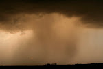
Thought I'd get this up since it turns out this is the highlight of 2009 so far (!) Unidirectional winds+ ridiculous temp/dewpoint spreads = nosebleed storms with stretched out updrafts that produced marginal winds and hail. Still, it was fun to test the equipment in preparation for the 2010 season... ha.
Initation near Clear Lake
 At least we had good background lighting
 Best looking storm of the day that died before we could play in it
 This one was fun, had some pretty cool motion


My best shot of the day
Driving home, why not sample some hail?
 This had better not become the highlight reel of 2009!
Initation near Clear Lake
At least we had good background lighting Best looking storm of the day that died before we could play in it This one was fun, had some pretty cool motionMy best shot of the day
Driving home, why not sample some hail?
This had better not become the highlight reel of 2009! Thanks Sara for your awesome driving skills!
Saturday, May 23, 2009
Monday's "potential" and blogging in general
So a lot of my friends tell me to start a blog. OK, hey, whatever. I'll give it a shot. Many ask about the weather and what it's going to do, well, I'm new at this, not a good forecaster, and I have the annoying tendency to wishcast a lot.
Suffering through the worst spring for severe weather I can ever remember. I've gone from high expectations in March, to hopefulness in April, to wishcasting in May. Now I'm just praying for rain. It's May and the lawn looks like it's August, the weather pattern looks like it's August, this is ridiculous. The only real active weather looks like it's up near the Arctic Circle.
So we have some potential for thunder at least come Monday. Instead of letting the models tell me it's going to stink, I have resorted to trying to find any glimmer of hope wherever I can. Won't be able to go far Monday, so here's to hoping some kind of instability can build closer to home along the cold front and we at least get a decent linear mess. I can't believe I just said that. But that's how far my expectations have fallen this year.
I have spent a lot of time over the last 2 years building my knowledge, observing, chasing a little, so as to be ready to do some serious chasing this year, and wouldn't you know it, there's nothing to chase. So, I apologize to those annoyed by my constant wishcasting, it's just a bit of a bitter pill to swallow...
It's hard to even look at the GFS beyond 4-5 days any more. Yeah, I checked it out this morning, and yes, it wants to toy with me yet again... hopefully it's on to something. More than likely it's just another teaser.
Subscribe to:
Posts (Atom)